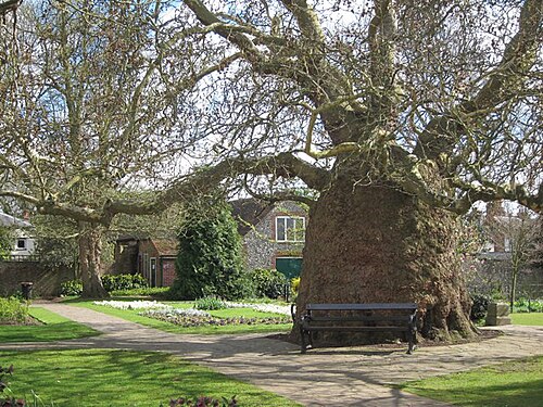
Mark Canterbury's seven baobab planes on a map and, by one local theory, they form a cross. This is one of the arms, a knobbly, swollen-trunked plane at the north-east corner of the castle ruins, beside Gas Street. The theory belongs to the local enthusiast Sadie Palmer, and nobody has shown that the pattern was planned rather than a coincidence of where planes happened to be put. What is not in doubt is the trunk. Like its relatives in Westgate Gardens and the cathedral precincts, it bulges as though something inside were pushing outward. The city's archaeological society first called these trees Oriental Planes; in 2014 the Natural History Museum's identification service told them the set is a clone of the London Plane with a viral infection. The sources still disagree on the name. No archive records when it went in. KentOnline says the baobab planes were planted more than 150 years ago, and a tree blog that toured them guesses the middle of the 19th century, so the range here stays wide. The most recent accounts of it standing are the archaeological society's pages and a 2019 newspaper piece. If you walk past and it is gone, or still very much there, tell us. The castle grounds are free and five minutes from Canterbury West.
From people who stood here
No notes yet
Did you visit the tree? Leave a note for the next visitor.
Getting there
Canterbury Castle, Castle Row / Gas Street, Canterbury CT1 2PR
You can recognise it by the knobbly, swollen trunk, unlike any ordinary plane. It stands at the north-east corner of the castle ruins, beside Gas Street.
Free. The castle ruins and their grounds are a public open space beside Gas Street; not checked for opening hours.
About 5 minutes' walk from Canterbury West station.
The line is our estimate of how much there is to see, not a measurement. Typical for this species where this tree stands; exact weeks shift with the year.
Sources
Where the facts on this page come from. The story was written with AI from these sources, and readers who know the tree correct it.